Click for more – Valid 7:00 AM CT
Throughout the course of today, a strong low pressure system is bringing various impacts stretching across the Upper Midwest to the Southeast. While different weather types are expected, all eyes are on the next HIGH storm risk of this year.
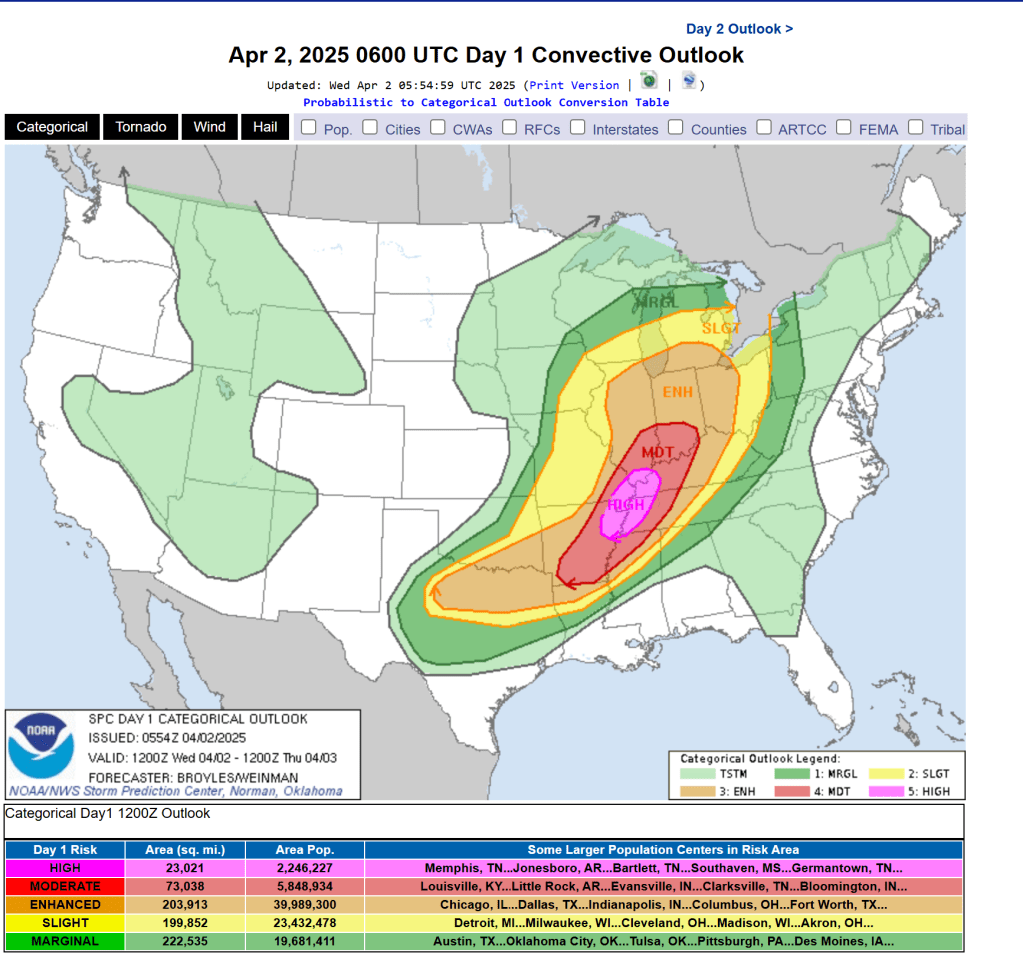
Though there are many factors to creating a thunderstorm outbreak, the main contributors with this scenario are the warm sector with a cold frontal boundary to follow. These features associated with the strong low pressure provide ample moisture and instability as well as the catalyst for storm initiation. With strong winds aloft (think up), it’s no wonder all eyes are on the Ohio and Tennessee Valleys.
So, we have some of the ingredients for potential storms. Where will it be most impactful? What will be the impacts?

Well, as instability increases throughout the day east of the cold front (warm sector), this means the energy for storms will build. But, as the cold front approaches, that energy could be released and introduce additional storm initiation. Currently, great instability along with a favorable wind regime is expected to set up near northeastern Arkansas, eastern Missouri, western Kentucky and Tennessee as highlighted by the HIGH risk. It is important to note this is always subject to change throughout the day due to new data, so following the latest updates can provide additional insight to real-time adjustment.
Once this initiation builds, the line of rain showers and embedded thunderstorms are likely to form, swinging west to east. With any severe storm, isolated wind gusts near or exceeding 55-65 knots (60-75 mph), large hail, lightning, and heavy rainfall are expected. Tornado development will be possible but will be subject to specific instances of favorable setup. Nonetheless, this line of storms will gradually lose energy as it moves east which contributes to the Enhanced and Moderate risks surrounding the High risk area.
Though these increasing percentages are no guarantee to the worst-case scenario, it does highlight the need for weather awareness.
Well… When?
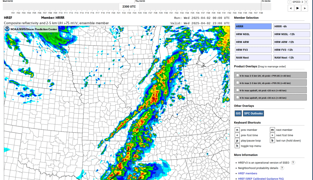
SPC HREF Member Viewer – SPC HREF Ensemble Viewer – Composite reflectivity
Short-range guidance notes the peak time period to start around 4-6 pm CT and continue through 7-8 pm CT. Thereafter, the line of showers and storms will begin to lose energy later this evening as they progress further east into northwestern MS, central KY/TN, eastern IN, and western OH. Some strong to severe storms will remain possible overnight as the cold front approaches the Mid-Atlantic though chances of occurrence will begin to decline.
Continuous rainfall, even beyond the severe storm threat, will also pose additional lingering flood impacts as ample moisture funnels into the region over the next couple of days. See the latest from the Weather Prediction Center Excessive Rainfall Outlook for more information.
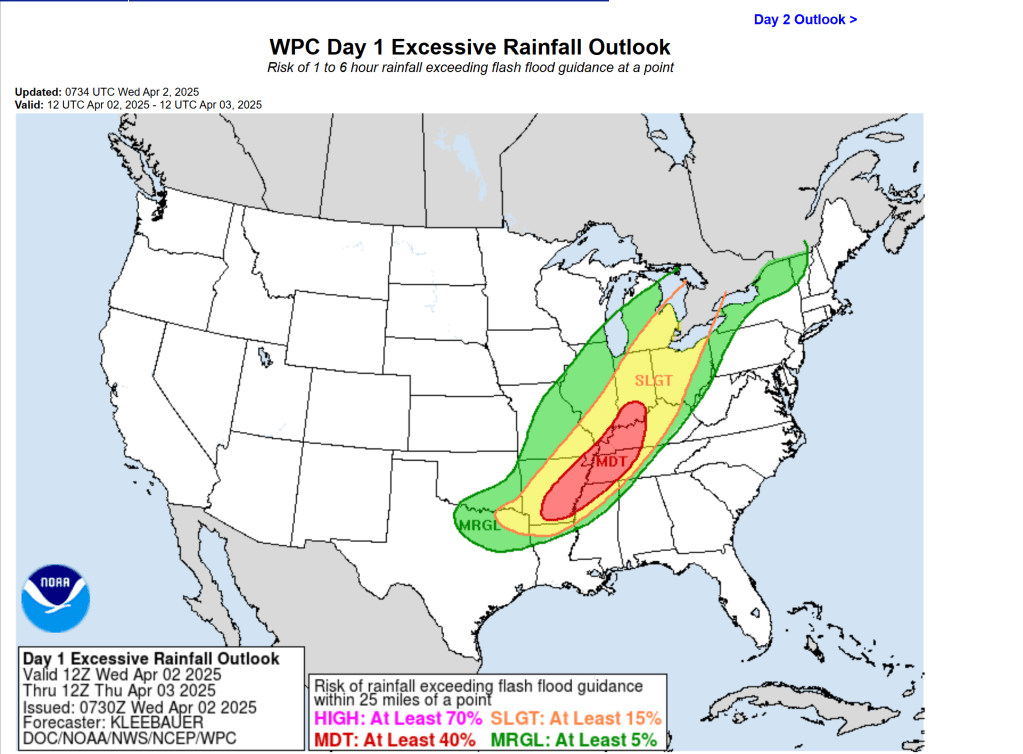
WPC Excessive Rainfall Outlook
A HIGH risk means an increased chance of occurrence and impact potential. Though there is no 100% guarantee, it does mean staying weather alert is key. Your local resources are valuable and ultimately can help you make weather decisions!

Leave a comment